

Recognising Great Nicobar’s salience to national security and commerce, ambitious development projects have been launched. The Army has been granted a Command for the archipelago. What about the civil administration, coastal border management, tribal development, law enforcement and a host of other civil administrative requirements? There is hardly any clarity on these issues.
An Archipelago at the Crossroads of the Indo-Pacific
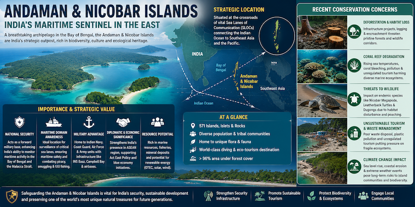
Stretching approximately 800 kilometres from north to south, the Andaman and Nicobar Islands occupy a distinctive position in India’s maritime geography. Comprising 836 islands, of which only 31 are inhabited, the archipelago forms an extension of the Arakan Yoma mountain range of Myanmar, submerged beneath the Bay of Bengal before re-emerging as an island chain. The Ten Degree Channel separates the Andaman group from the Nicobars, while Indira Point on Great Nicobar marks India’s southernmost extremity.
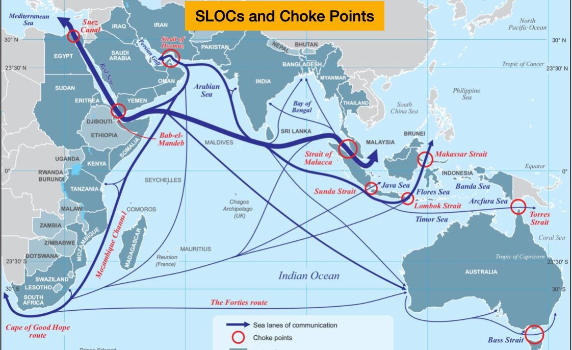
Their importance derives not merely from their geographical separation from mainland India, but from their proximity to some of the world’s busiest maritime routes. The islands lie close to the approaches to the Strait of Malacca, through which substantial volumes of global trade and energy supplies move between the Indian and Pacific Oceans. Great Nicobar, in particular, overlooks the western approaches to the Malacca and Singapore straits.
This location gives India a maritime presence far beyond its mainland coastline. It offers opportunities to monitor shipping, protect sea lines of communication (SLOCs), support naval operations and strengthen engagement with Southeast Asia. In an era when economic prosperity and national security are increasingly linked to maritime connectivity, the strategic value of these islands is difficult to overstate.
 Yet India took decades to fully appreciate their potential.
The Islands India Almost Lost
The history of the Andaman and Nicobar Islands is closely intertwined with colonial competition and India’s struggle for independence. The Chola rulers incorporated the Nicobar Islands into their maritime trading networks in the eleventh century. European powers subsequently sought control of the archipelago, with the Danes establishing a presence in Nicobar in 1755. The British followed with attempts to establish settlements, but disease and difficult conditions repeatedly frustrated their efforts.
The British re-established their presence in the Andamans in 1858, following the Revolt of 1857. The Cellular Jail, completed in 1906, became an enduring symbol of colonial repression and the sacrifices made by India’s freedom fighters. During the Second World War, Japanese forces occupied the islands before British control was restored.
The islands’ strategic value was also recognised during the 1947 transfer of power. British military planners considered retaining them outside independent India because of their importance to imperial maritime and air communications. An early draft of the Indian Independence Bill reportedly provided for their separation from British India. The omission of the islands from proposed independence documents later drew public attention and provoked strong opposition.
The Muslim League, led by Muhammad Ali Jinnah, also sought their allocation to Pakistan, citing strategic considerations and the movement of personnel between its eastern and western wings. These claims were rejected, and the islands became part of independent India. Their strategic significance was thus recognised even before independence, although their full military and economic potential remained underdeveloped for decades.
Since 1956, the islands have been administered as a Union Territory.
A Maritime Opportunity India Must Seize
The Andaman and Nicobar Islands provide India with a forward position in the eastern Indian Ocean. Their location enables monitoring maritime movement, supporting naval and air operations, and contributing to the security of critical shipping routes.
Great Nicobar is particularly significant. It lies close to the principal east-west maritime corridor connecting the Indian Ocean with the Pacific. This gives it potential as a logistics, surveillance and operational hub. Properly developed, it could support the deployment of warships, aircraft, surveillance platforms and other defence assets, while strengthening India’s capacity to respond to emerging security challenges.
China’s expanding presence across the Indian Ocean littoral adds urgency to this requirement. Its network of port and infrastructure investments, often described as the ‘String of Pearls’, includes facilities and projects at Gwadar, Hambantota, Kyaukphyu, and other locations across the region. Although these facilities differ in ownership, purpose and present military utility, their cumulative strategic implications merit attention.
India cannot afford to leave its eastern maritime approaches inadequately protected. The islands should therefore be developed as an integral part of a wider maritime strategy rather than as isolated infrastructure projects.
A comprehensive Defence and Maritime Strategy (DMS) is essential. It should define India’s objectives for both defending its island territories and projecting maritime power across the eastern Indian Ocean. It must specify force requirements, deployment locations, surveillance arrangements, logistics, infrastructure and contingency planning. The strategy should encompass the Andaman and Nicobar Islands as well as Lakshadweep and India’s wider Indian Ocean interests.
The establishment of the Andaman and Nicobar Command (ANC), India’s first integrated tri-service command, marks an important step towards recognising its role in national defence. The Tri-Service Andaman and Nicobar Command provides an institutional foundation. However, its capabilities and supporting infrastructure need strengthening to match the responsibilities envisaged for the islands.
Coastal Security, Civil Administration and Policing
While there is extensive debate in the public domain about military capability development, there is total silence on civilian infrastructure and asset development. The whole area is extremely sensitive from security, environmental, and tribal community perspectives. The coastal security apparatus, intelligence and surveillance capability, policing mechanisms, and civilian administration must be designed before work commences. Added infrastructure through educational, health, and housing components should also be factored in. The Central Industrial Security Force (CISF) should be brought in from the start of transhipment port design.
Overall defence and security planning and civil administration must proceed hand in hand and integrate with major commercial development. A strategically important port cannot remain secure unless the whole-of-government approach is applied to protect it as it is developed.
Great Nicobar: An Economic and Strategic Gateway
The Great Nicobar Island Development Project represents an opportunity to combine commercial expansion with strategic capability. Its central component is the proposed International Container Transhipment Port (ICTP) at Galathea Bay.
India currently depends substantially on foreign ports, particularly Singapore and Colombo, for container transhipment. Establishing a major facility within Indian territory could reduce this dependence, retain a greater share of transhipment revenue and strengthen India’s position in regional maritime trade.
Galathea Bay offers a natural water depth of approximately 20–22 metres, potentially enabling it to accommodate some of the world’s largest container vessels with relatively limited dredging. Its proximity to the main east-west shipping corridor is another major advantage. Great Nicobar lies approximately 22 nautical miles north of this route, potentially allowing vessels to call at the port without the significant deviation required to reach some competing hubs.
The proposed project envisages phased development over approximately three decades. Initial capacity is expected to be around four million twenty-foot equivalent units (TEUs) annually, with subsequent expansion towards 14 million TEUs. The wider development plan includes a greenfield international airport, a power plant with a proposed capacity of 450 MVA, and a township with housing and essential facilities for port and logistics personnel.
The economic benefits could extend well beyond container handling. Port-related activity can generate employment in warehousing, logistics, cold-chain management, bunkering, ship repair, maritime finance and insurance. It could also create a wider ecosystem of maritime services and improve India’s connectivity with Southeast Asia.
However, the project’s scale and remoteness demand careful commercial scrutiny. A detailed market assessment must establish the likely demand, shipping-line commitments, operating costs and competitive advantages before major investments are made. The port must be marketed internationally well before completion.
Its strategic value may justify a long-term national investment, but commercial viability cannot be assumed. Both objectives must be examined rigorously.
Environmental Costs and the Vulnerability of Island Ecosystems
The development of Great Nicobar raises serious environmental questions. Its tropical rainforests, mangroves, coral reefs and coastal ecosystems support an unusually rich range of biodiversity. Many species are endemic to the island, making habitat disturbance particularly consequential.
The project involves diverting substantial forest land and clearing tropical rainforest. The source material estimates that approximately 13,075 hectares may be affected, including around 130 square kilometres of rainforest. It also identifies potential threats to mangroves, old-growth trees, endemic plants and wildlife habitats.
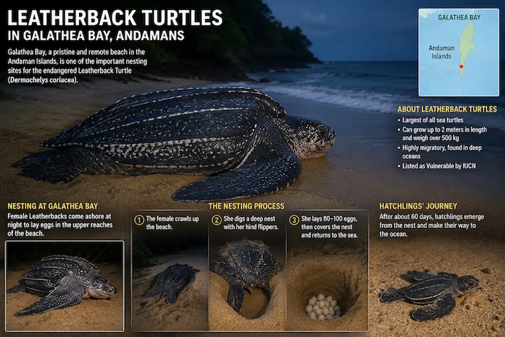 Species of concern include the leatherback turtle, Nicobar pigeon, Nicobar long-tailed macaque and Nicobar megapode. Changes to the Galathea Bay coastline and the proposed port infrastructure could affect nesting areas, terrestrial habitats and marine ecosystems. Construction activity may also disturb coral reefs and increase pressure on coastal environments.
The environmental consequences must be assessed locally, taking account of the island’s unique species, ecological relationships and limited capacity to absorb disturbance.
The islands are also vulnerable to earthquakes and tsunamis. Infrastructure must therefore be designed for severe seismic conditions, incorporating appropriate engineering standards, tsunami modelling and coastal resilience measures.
Development and environmental protection need not be mutually exclusive. But environmental safeguards must be integral to the project from the outset, not corrective measures introduced after construction has begun.
Indigenous Communities Must Remain Central
The human dimension is at least as important as the ecological one. Great Nicobar is home to indigenous communities whose relationship with the island predates modern administration and development.
The Shompen, classified as a Particularly Vulnerable Tribal Group, are semi-nomadic forest dwellers who depend substantially on the natural environment for their livelihoods. Their limited contact with outsiders is an important aspect of their way of life. Their small population and vulnerability to external diseases make uncontrolled contact particularly concerning.
The proposed development around Galathea Bay raises questions about protecting their traditional habitat and access to forest resources. Even if designated habitation areas remain formally protected, construction activity and the arrival of large workforces could alter the surrounding environment and increase the risk of unwanted contact.
The Nicobarese communities also have important historical, cultural and livelihood interests in the islands. Planning decisions must account for their settlements, agriculture, and coastal way of life. Families resettled on Great Nicobar, including descendants of former servicemen, add another dimension to the island’s social landscape.
Compliance with the Forest Rights Act, 2006, and other applicable protections must be demonstrated through transparent processes, not treated as a procedural formality. Consultation must be meaningful and sensitive to each community’s distinct circumstances.
Tribal habitation zones should be clearly demarcated and protected from tourism and unauthorised access. Development agencies must ensure that indigenous communities are not exposed to avoidable health, cultural or environmental risks. At the same time, protection should not be used to deny communities appropriate safeguards, emergency assistance, or support when required.
Local participation can also be encouraged through carefully designed employment and training opportunities for communities able and willing to engage with the wider economy. Any such programme must respect the autonomy and specific protections of particularly vulnerable groups.
Making the Project Secure, Viable and Accountable
The success of the Great Nicobar project will depend heavily on the quality of its planning and implementation. The proposed port is more than 720 nautical miles from mainland India. Construction materials, equipment, labour, fuel and other essential supplies will have to be transported over long distances, often under challenging weather conditions.
The island currently has limited infrastructure and basic services. Constraints on drinking water, fuel availability, transport, housing, and construction resources could become more acute as the workforce expands. These realities must be addressed before large-scale construction gathers momentum.
Institutional responsibility also requires clarity. The Shyama Prasad Mookerjee Port, Kolkata, has been identified as the agency entrusted with important responsibilities for the ICTP’s planning and development. At the same time, the Andaman and Nicobar Islands Integrated Development Corporation (ANIIDCO) has a significant local coordination role. Their respective mandates, technical capacities and accountability arrangements must be clearly defined.
A project of this scale requires leadership with substantial experience in port engineering, maritime infrastructure and complex project management. Fortunately, India has enough homegrown expertise in such implementations that require coordination across civilian, environmental, and defence requirements.
The project should also adopt stringent seismic and tsunami-resilient engineering standards. These are essential conditions for the long-term safety of the port, airport, township and supporting infrastructure.
A National Undertaking Requiring Strategic Patience
The Great Nicobar development project could strengthen India’s maritime position, expand its participation in international trade, and provide a more substantial forward presence in the eastern Indian Ocean. Its proximity to major shipping routes gives it an advantage that is hard to replicate elsewhere.
But strategic ambition must be matched by institutional competence, commercial realism and environmental responsibility. The project should not be rushed merely because its location offers significant advantages. Its logistics, financial assumptions, security architecture and ecological safeguards require sustained scrutiny.
Ultimately, Great Nicobar must be viewed as a long-term national investment. The islands India almost lost in 1947 could become among its most valuable commercial and strategic assets in the Indo-Pacific. Realising that promise will require not only vision and political resolve, but also careful planning, professional execution and respect for the extraordinary natural and human heritage of the archipelago.